Estuarine (E)
SYSTEM = ESTUARINE
(E) Estuarine (Salt marshes and brackish tidal water)
Definition:
The Estuarine System consists of deepwater tidal habitats and adjacent tidal wetlands that are usually semienclosed by land but have open, partly obstructed, or sporadic access to the open ocean, and in which ocean water is at least occasionally diluted by freshwater runoff from the land. The salinity may be periodically increased above that of the open ocean by evaporation. Along some low-energy coastlines there is appreciable dilution of seawater. Offshore areas with typical estuarine plants and animals, such as red mangroves (Rhizophora mangle) and eastern oysters (Crassostrea virginica), are also included in the Estuarine System.
The Estuarine System is defined in terms of Halinity and tidal influence. If tidal influence is only partially obstructed by weirs or tide (flap) gates or if tidal flux is accomplished by an underground connection, the area should be classified as Estuarine. However, if an area has been completely cut off from tidal action (e.g. totally obstructed by a dike), the area, regardless of its location or salinity would then fall into the Lacustrine or Palustrine Systems.
Limits:
The Estuarine System extends
1. Upstream and landward to where ocean-derived salts measure less than 0.5% during the period of average annual low flow;
2. To an imaginary line closing the mouth of a river, bay, or sound;
3. To the seaward limit of wetland emergents, shrubs, or trees where they are not included in (2). The Estuarine System also includes offshore areas of continuously diluted seawater.
Description:
The Estuarine System includes both estuaries and lagoons. It s more strongly influenced by its association with land than is the Marine System. In terms of wave action, estuaries are generally considered to be low-energy systems.
Estuarine water regimes and water chemistry are affected by one or more of the following forces: oceanic tides, precipitation, freshwater runoff from land areas, evaporation, and wind. Estuarine salinities range from hyperhaline to. The salinity may be variable, as in hyperhaline lagoons (e.g., Laguna Madre, Texas) and most brackish estuaries (e.g., Chesapeake Bay, Virginia-Maryland); or it may be relatively stable, as in sheltered euhaline embayments (e.g., Chincoteague Bay, Maryland) or brackish embayments with partly obstructed access or small tidal range (e.g., Pamlico Sound, North Carolina).
The primary data used in identifying Estuarine Systems is the salinity and plant communities inhabiting the areas. Lagoons that are hyperhaline are also included in the Estuarine System. If the mouth of an Estuarine river has been extended into the Marine System by parallel breakwater, the seaward limit of breakwaters forms the Estuarine/Marine break. The limit of the Estuarine System is further identified by the seaward limit of the wetland emergents, shrubs, or trees where these plants grow seaward of the line closing the mouth of a river, bay, or sound.
The seaward limit of Mollusks reefs occurring outside of the line closing the mouth of a river, bay, or sound is also used to describe the Estuarine/Marine break. Bottom contour maps may be of some use in delineating the Marine/Estuarine demarcation in these instances.
The location of the break separating the Estuarine System from the Tidal Riverine System can often be judged by identifying the upstream limit of salt tolerant vegetation. This vegetation change is observable on aerial photographs in many coastal areas.
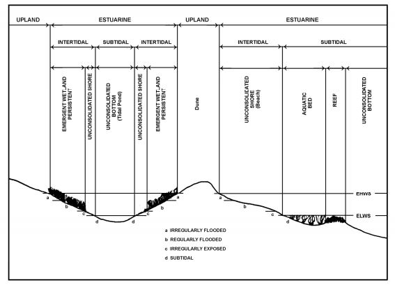
Subsystems:
Subtidal (1) - The substrate in these habitats is continuously covered with tidal water (i.e., located below extreme low water).
Intertidal (2) - The substrate in these habitats is flooded and exposed by tides; includes the associated splash zone.
Classes: Rock Bottom, Unconsolidated Bottom, Aquatic Bed, Reef, Streambed, Rocky Shore, Unconsolidated Shore, Emergent Wetland, Scrub-Shrub Wetland, and Forested Wetland.
Created with the Personal Edition of HelpNDoc: Free Qt Help documentation generator