Wetland Keys
WETLAND KEYS
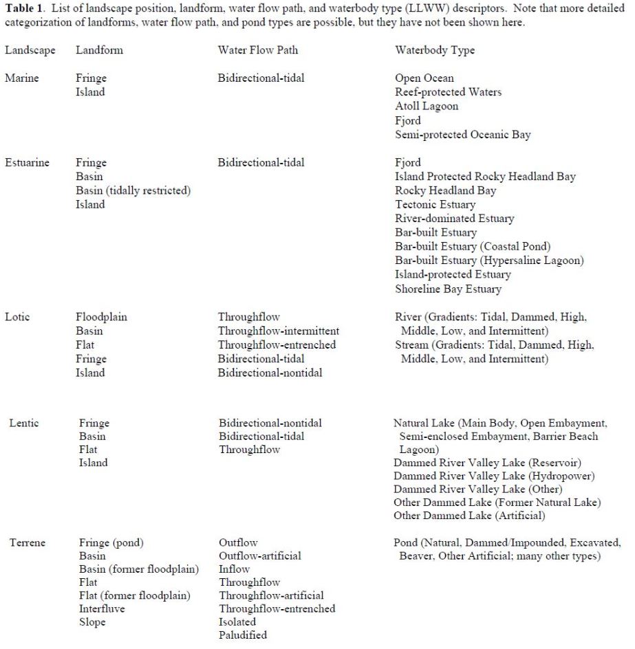
Three keys are provided to identify wetland landscape position and landform for individual wetlands: Key A for classifying the former and Keys B and C for the latter (for inland wetlands and coastal wetlands, respectively). A fourth key - Key D - addresses the flow of water associated with wetlands. Table 1 lists the LLWW descriptors. It gives readers a good idea of what the various combinations may be. Also see wetland codes in one of the following sections.
Users should first identify the landscape position associated with the subject wetland following Key A-1. Afterwards, using Key B-1 for inland wetlands and Key C-1 for salt and brackish wetlands, users will determine the associated landform. The landform keys include provisions for identifying specific regional wetland types such as Carolina bays, pocosins, flatwoods, cypress domes, prairie potholes, playas, woodland vernal pools, West Coast vernal pools, interdunal swales, and salt flats. Key D-1 addresses water flow path descriptors. Various other modifiers may also be applied to better describe wetlands, such as headwater areas; these are included in the four main keys.
Besides the keys provided, there are numerous other attributes that can be used to describe the condition of wetlands. Some examples are other descriptors that address resource condition could be ones that emphasize human modification, (e.g., natural vs. altered, with further subdivisions of the latter descriptor possible), the condition of wetland buffers, or levels of pollution (e.g., no pollution [pristine], low pollution, moderate pollution, and high pollution). Addressing wetland condition, however, was beyond our immediate goal of describing wetlands from a hydrogeomorphic standpoint.
Created with the Personal Edition of HelpNDoc: Full-featured Documentation generator