NWI Plus (LLWW) Descriptions
NWI PLUS CLASSIFICATION
(Information taken from Dichotomous Keys and Mapping Codes for Wetland Landscape Position, Landform, Water Flow Path, and Waterbody Type Descriptors - US FWS)
INTRODUCTION
A wide variety of wetlands have formed across the United States. To describe this diversity and to inventory wetland resources, government agencies and scientists have devised various wetland classification systems (Tiner 1999). Features used to classify wetlands include vegetation, hydrology, water chemistry, origin of water, soil types, landscape position, landform (geomorphology), wetland origin, wetland size, and ecosystem form/energy sources.
The U.S. Fish and Wildlife Service's wetland and deepwater habitat classification (Cowardin et al. 1979) is the national standard for wetland classification. This classification system emphasizes vegetation, substrate, hydrology, water chemistry, and certain impacts (e.g., partly drained, excavated, impounded, and farmed). These properties are important for describing wetlands and separating them into groups for inventory and mapping purposes and for natural resource management. They do not, however, include some abiotic properties important for evaluating wetland functions (Brinson 1993). Moreover, the classification of deepwater habitats is limited mainly to general aquatic ecosystem (marine, estuarine, lacustrine, and riverine) and bottom substrate type, with a few subsystems noted for riverine deepwater habitats. The Service's classification system would benefit from the application of additional descriptors that more fully encompass the range of characteristics associated with wetlands and deepwater habitats.
In the early 1990s, Mark Brinson created a hydrogeomorphic (HGM) classification system to serve as a foundation for wetland evaluation (Brinson 1993). He described the HGM system as "a generic approach to classification and not a specific one to be used in practice" (Brinson 1993, p. 2). This system emphasized the location of a wetland in a watershed (its geomorphic setting), its sources of water, and its hydrodynamics. The system was designed for evaluating similar wetlands in a given geographic area and for developing a set of quantifiable characteristics for "reference wetlands" rather than for inventorying wetland resources (Smith et al. 1995). A series of geographically focused models or "function profiles" for various wetland types have been created and are in development for use in functional assessment (e.g., Brinson et al. 1995, Ainslie et al. 1999, Smith and Klimas 2002).
NEED FOR NEW DESCRIPTORS
The Service's National Wetlands Inventory (NWI) Program has produced wetland maps for 91 percent of the coterminous United States and 35 percent of Alaska. Digital data are available for 46 percent of the former area and for 18 percent of the latter. Although these data represent a wealth of information about U.S. wetlands, they lack hydrogeomorphic and other characteristics needed to perform assessments of wetland functions over broad geographic areas. Using geographic information system (GIS) technology and geospatial databases, it is now possible to predict wetland functions for watersheds - a major natural resource planning unit. Watershed managers could make better use of NWI data if additional descriptors (e.g., hydrogeomorphic- type attributes) were added to the current NWI database. Watershed-based preliminary
assessments of wetland functions could be performed. This new information would also permit more detailed characterizations of wetlands for reports and for developing scientific studies and lists of potential reference wetland sites.
BACKGROUND ON DEVELOPMENT OF KEYS
Since the Cowardin et al. wetland classification system (1979) is the national standard and forms the basis of the most extensive wetland database for the country, it would be desirable to develop additional modifiers to enhance the current data. This would greatly increase the value of NWI digital data for natural resource planning, management, and conservation. Unfortunately, Brinson's "A Hydrogeomorphic Classification of Wetlands" (1993) was not designed for use with the Service's wetland classification. He used some terms from the Cowardin et al. system but defined them differently (e.g., Lacustrine and Riverine). Consequently, the Service needed to develop a set of hydrogeomorphic-type descriptors that would be more compatible with its system. Such descriptors would bridge the gap between these two systems, so that NWI data could be used to produce preliminary assessments of wetland functions based on characteristics identified in the NWI digital database. In addition, more descriptive information on deepwater habitats would also be beneficial. For example, identification of the extent of dammed rivers and streams in the United States is a valuable statistic, yet according to the Service's classification dammed rivers are classified as Lacustrine deepwater habitats with no provision for separating dammed rivers from dammed lacustrine waters. Differentiation of estuaries by various properties would also be useful for national or regional inventories.
Recognizing the need to better describe wetlands from the abiotic standpoint in the spirit of the HGM approach, the Service developed a set of dichotomous keys for use with NWI data (Tiner 1997b). The keys bridge the gap between the Service's wetland classification and the HGM system by providing descriptors for landscape position, landform, water flow path and waterbody type (LLWW descriptors) important for producing better characterizations of wetlands and deepwater habitats. The LLWW descriptors for wetlands can be easily correlated with the HGM types to make use of HGM profiles when they become available. The LLWW attributes were designed chiefly as descriptors for the Service's existing classification system (Cowardin et al. 1979) and to be applied to NWI digital data, but they can be used independently to describe a wetland or deepwater habitat. Consequently, there is some overlap with Cowardin et al. since some users may wish to use these descriptors without reference to Cowardin et al.
The first set of dichotomous keys was created to improve descriptions of wetlands in the northeastern United States (Tiner 1995a, b). They were initially used to enhance NWI data for predicting functions of potential wetland restoration sites in Massachusetts (Tiner 1995a, 1997a). Later, the keys were modified for use in predicting wetland functions for watersheds nationwide (Tiner 1997b, 2000). A set of keys for waterbodies was added to improve the Service's ability to characterize wetland and aquatic resources for watersheds.
The keys are periodically updated based on application in various physiographic regions. This version is an update of an earlier set of keys published in 1997 and 2000 (Tiner 1997b, 2000). Relatively minor changes have been made, including the following: 1) added "drowned river-mouth" modifier to the Fringe and Basin landforms (for use in areas where rivers empty into large lakes such as the Great Lakes where lake influences are significant), 2) added "connecting channels" to river type (to address concerns in the Great Lakes to highlight such areas), 3) added "Throughflow-intermittent" water flow path (to separate throughflow wetlands along intermittent streams from those along perennial streams), 4) added "Throughflow-artificial" and "Outflow- artificial" to water flow path (to identify former "isolated" wetlands or fragmented wetlands that are now throughflow or outflow due to ditch construction), 5) revised the lake key to focus on permanently flooded deepwater sites (note: shallow and seasonally to intermittently flooded sites are wetlands) and added "open embayment" modifier, and 6) revised the estuary type key (consolidated some types). This version also clarifies that a terrene wetland may be associated with a stream where the stream does not periodically flood the wetland. In this case, the stream has relatively little effect on the wetland's hydrology. This is especially true for numerous flatwood wetlands. It also briefly discusses how the term "isolated" is applied relative to surface water and ground water interactions. In the near future, illustrations will be added to this document to aid users in interpretations.
USE OF THE KEYS
Two sets of dichotomous keys (composed of pairs of contrasting statements) are provided - one for wetlands and one for waterbodies. Vegetated wetlands (e.g., marshes, swamps, bogs, flatwoods, and wet meadows) and periodically exposed nonvegetated wetlands (e.g., mudflats, beaches, and other exposed shorelines) should be classified using the wetland keys, while the waterbody keys should be used for permanent deep open water habitats (subtidal or >6.6 feet deep for nontidal waters). Some sites may qualify as both wetlands and waterbodies. A good example is a pond. Shallow ponds less than 20 acres in size meet the Service's definition of wetland, but they are also waterbodies. Such areas can be classified as both wetland and waterbody, if desirable. However, we recommend that ponds be classified using the waterbody keys. Another example would be permanently flooded aquatic beds in the shallow water zone of a lake. We have classified them using wetland hydrogeomorphic descriptors, yet they also clearly represent a section of the lake (waterbody). This approach has worked well for us in producing watershed-based wetland characterizations and preliminary assessments of wetland functions.
USES OF ENHANCED DIGITAL DATABASE
Once they are added to existing NWI digital data, the LLWW characteristics (e.g., landscape position, landform, water flow path, and waterbody type) may be used to produce a more complete description of wetland and deepwater habitat characteristics for watersheds. The enhanced NWI digital data may then be used to predict the likely functions of individual wetlands or to estimate the capacity of an entire suite of wetlands to perform certain functions in a watershed. Such work has been done for several watersheds including Maine's Casco Bay watershed and the Nanticoke River and Coastal Bays watersheds in Maryland, the Delaware portion of the Nanticoke River, and numerous small watersheds in New York (see Tiner et al. 1999, 2000, 2001; Machung and Forgione 2002; Tiner 2002; see sample reports on the NWI website:http://wetlands.fws.gov for application of the LLWW descriptors). These characterizations are based on our current knowledge of wetland functions for specific types (Tiner 2003) and may be refined in the future, as needed, based on the applicable HGM profiles and other information. The new terms can also be used to describe wetlands for reports of various kinds including wetland permit reviews, wetland trend reports, and other reports requiring more comprehensive descriptions of individual wetlands.
WETLAND KEYS
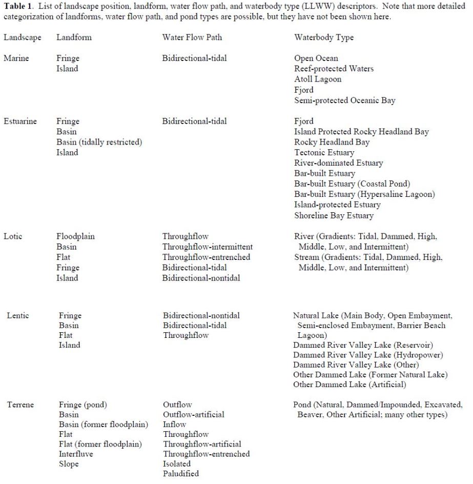
Three keys are provided to identify wetland landscape position and landform for individual wetlands: Key A for classifying the former and Keys B and C for the latter (for inland wetlands and coastal wetlands, respectively). A fourth key - Key D - addresses the flow of water associated with wetlands. Table 1 lists the LLWW descriptors. It gives readers a good idea of what the various combinations may be. Also see wetland codes in one of the following sections.
Users should first identify the landscape position associated with the subject wetland following Key A-1. Afterwards, using Key B-1 for inland wetlands and Key C-1 for salt and brackish wetlands, users will determine the associated landform. The landform keys include provisions for identifying specific regional wetland types such as Carolina bays, pocosins, flatwoods, cypress domes, prairie potholes, playas, woodland vernal pools, West Coast vernal pools, interdunal swales, and salt flats. Key D-1 addresses water flow path descriptors. Various other modifiers may also be applied to better describe wetlands, such as headwater areas; these are included in the four main keys.
Besides the keys provided, there are numerous other attributes that can be used to describe the condition of wetlands. Some examples are other descriptors that address resource condition could be ones that emphasize human modification, (e.g., natural vs. altered, with further subdivisions of the latter descriptor possible), the condition of wetland buffers, or levels of pollution (e.g., no pollution [pristine], low pollution, moderate pollution, and high pollution). Addressing wetland condition, however, was beyond our immediate goal of describing wetlands from a hydrogeomorphic standpoint.
Created with the Personal Edition of HelpNDoc: Easy EBook and documentation generator