Georgia Functional Assessment
INTRODUCTION
in 2010, the Georgia Department of Natural Resources (GA DNR) updated National Wetlands Inventory (NWI) data for the state’s six coastal counties. The U.S. Fish and Wildlife Service (Service) has recognized the potential application of NWI data for watershed assessments, but realized that other attributes would have to be added to the data to facilitate functional analysis. In the early 1990s, Dr. Mark Brinson conceived a hydrogeomorphic approach to wetland functional assessment that uses comparison of field-verified properties of existing wetlands to those from a set of reference wetlands as a means of assessing a wetland’s proximity to or departure from reference condition (Brinson 1993a). This approach provided the impetus for the Service to develop other attributes to expand the NWI database and make it more useful as a tool for landscape-level functional assessment of wetlands.
In the mid-1990s, the NWI developed a set of abiotic descriptors to describe a wetland's landscape position, landform, water flow path, and waterbody type (LLWW descriptors; Tiner 1995, 1996a, b). Use of the initial set of keys for pilot watershed projects led to a refinement and expansion of the keys in subsequent years (Tiner 1997a, b, 2000, 2002, 2003a). The expanded NWI database is called NWIPlus because it significantly increases the amount of information collected for mapped wetlands (Tiner 2010). These data allow for improved characterization of wetlands across the landscape and make it possible to predict wetland functions at the landscape, watershed, or regional scale. Numerous projects have created NWIPlus data and used the data to better describe wetlands in watersheds or other specific geographic areas and produce preliminary assessments of wetland functions (Table 1). In conducting these studies in the Northeast, the Service worked with local and regional wetland experts to develop relationships between wetland characteristics recorded in the database and wetland functions. The results reflect our best approximation of what types of wetlands are likely to perform certain functions at significant levels based on the characteristics in the NWIPlus database. Besides the Service’s applications of these techniques, several states have been building NWIPlus or similar databases or have plans to conduct at least a pilot study including Kansas, Michigan, Minnesota, Montana, New Mexico, and Wisconsin (Tiner 2010). The State of Delaware has worked with the Service to update NWI data and create a statewide NWIPlus database, and will use the information to produce a series of reports on wetland status, recent and historic trends, wetland functions, and potential wetland restoration sites.
Note: NWIPlus databases are not a standard product of the NWI Program as the program’s mapping funds are extremely limited. Creation of such databases is done where user-funded or as part of NWI updates by the Service on a case-by-case basis depending on available funding and regional priorities.
The State of Georgia added LLWW descriptors to their updated wetland inventory data to create an NWIPlus database for six coastal counties. The NWIPlus data will be used to better characterize wetlands in this region and to be able to predict wetland functions at the landscape level. In order to do the latter, the relationships (formerly called correlations) developed for use in the northeastern United States were introduced to and reviewed by a group of Georgia scientists from federal, state, and local agencies, non-profit organizations, and academic institutions at an August 31, 2010 workshop on Little St. Simons Island. The peer group provided comments that were used to re-evaluate the relationships and tailor them to coastal Georgia. In cases where there were differences in opinions, the points were considered and decisions were made by consensus between the Coastal Resources Division of the Georgia Department of Natural Resources, Atkins North America (formerly PBS&J Inc., Raleigh, NC), and Ralph Tiner (U.S. Fish and Wildlife Service, Region 5, Hadley, MA).
The purpose of this report is to explain how the NWIPlus data could be and was used for predicting wetland functions at the landscape-level for coastal Georgia and the rationale for assigning certain biotic and/or abiotic characteristics to eleven wetland functions: 1) surface water detention, 2) coastal storm surge detention, 3) streamflow maintenance, 4) nutrient transformation, 5) carbon sequestration, 6) sediment and other particulate retention, 7) bank and shoreline stabilization, 8) provision of fish and aquatic invertebrate habitat, 9) provision of waterfowl and waterbird habitat, 10) provision of other wildlife habitat, and 11) provision of habitat for unique, uncommon or highly diverse wetland plant communities.
CREATING THE NWI PLUS DATABASE
A set of abiotic attributes have been developed to increase the information contained in the NWI database and to create a NWIPlus database. Four groups of attributes describe:
• landscape position (relationship of a wetland to a waterbody if present: marine—ocean, estuarine—tidal brackish, lotic—river/stream, lentic—lake/ reservoir, and terrene—not significantly affected by such waters, or no waterbody present, or the source of a stream);
• landform (physical shape of the wetland—basin, flat, floodplain, fringe, island, and slope);
• water flow path (inflow, outflow, throughflow, isolated, bidirectional-nontidal, and bidirectional-tidal); and
• waterbody type (different types of estuaries, rivers, lakes, and ponds).
Collectively, they are known as LLWW descriptors, which represent the first letter of each descriptor (landscape position, landform, water flow path, and waterbody type). Dichotomous keys have been developed to interpret these attributes (Tiner 2003b; they will be amended in 2011 to reflect results of recent applications). Other modifiers are also included in these keys to further describe wetland characteristics. LLWW descriptors are added to the NWI database by interpreting topography from digital raster graphics (DRGs) or digital elevation model data (DEMs), stream courses from the National Hydrography Dataset (NHD) and/or aerial imagery, and waterbody types from aerial imagery (Figure 1). The interpretations are done by employing some automated GIS-routines coupled with manual review and interpretation by wetland specialists. This effort now increases the NWI workload by less than 10 percent.
The NWIPlus database adds value and increases the functionality of the original NWI database. Besides providing more features that can be used to predict wetland functions from the NWI database, NWIPlus makes it possible to better characterize the nation’s wetlands. For example, all the palustrine wetlands, which account for 95 percent of the wetlands in the conterminous United States, can now be linked to rivers, streams, lakes, and ponds where appropriate, so that the acreage of floodplain wetlands, lakeside wetlands, and geographically isolated wetlands can be reported. The Wetlands Subcommittee of the Federal Geographic Data Committee (FGDC) recognized the value added by the LLWW descriptors and recommended that they be included in wetland mapping to increase the functionality of wetland inventory databases (FGDC Wetlands Subcommittee 2009).
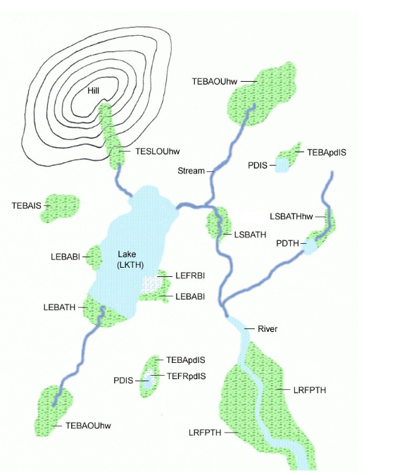
Figure 1. Examples of application of LLWW descriptors to nontidal wetlands. Coding: Landscape position = LE – Lentic, TE – Terrene, LR – Lotic River, LS – Lotic Stream; Landform = BA – Basin, FP – Floodplain, FR – Fringe, SL – Slope; Water Flow Path = BI – Bidirectional-nontidal, IS – Isolated, OU – Outflow, TH – Throughflow; Other descriptors: PD – Pond, LK – Lake, hw – headwater, and pd – pond-bordering wetland. Note: If desired, ponds and lakes can be further classified with landscape position resulting in codes of TEPDIS for the isolated ponds and LSLKTH for the lake shown in this figure.
LIMITATION OF THE PRELIMINARY WETLAND FUNCTIONAL ASSESSMENT
Source data are a primary limiting factor for landscape-level functional assessment. NWI digital data and existing stream data (e.g., National Hydrography Dataset) are used as the foundation for these assessments. All wetland and stream mapping has limitations due to scale, photo quality, date of the survey, and the difficulty of photointerpreting certain wetland types (especially evergreen forested wetlands and drier-end wetlands; see Tiner 1997c, 1999 for details) and narrow or intermittent streams especially those flowing through dense evergreen forests and beneath built-up lands.
Recognizing source data limitations, it is equally important to understand that this type of functional assessment is a preliminary one based on wetland characteristics interpreted through remote sensing and using the best professional judgment of various specialists to develop relationships between wetland characteristics in the database and wetland functions. It is designed for landscape- or watershed-level assessments covering large geographic areas.
Wetlands are rated based on their biotic or abiotic characteristics as having high or moderate potential for supporting a wetland function. Wetlands not assigned a rating are assumed to have little or no potential for providing such function at a significant level. The ratings are based on a review of the literature and best professional judgment by numerous scientists studying wetlands from public agencies, private non-government organizations, and academia. Also, no attempt is made to produce a more qualitative ranking for each function (comparing to a “reference” type representing a wetland of the type in the “best” condition, or on size or the degree to which it actually performs a function given opportunity and adjacent land uses) or for each wetland based on multiple functions as this would require more input from others and more data, well beyond the scope of this type of broad-scale evaluation. For a technical review of wetland functions, see Mitsch and Gosselink (2007) and for a broad overview, see Tiner (2005a).
Functional assessment of wetlands can involve many parameters. Typically such assessments have been done in the field on a case-by-case basis, considering observed features relative to those required to perform certain functions or by actual measurement of performance. The preliminary assessments based on remotely sensed information do not seek to replace the need for field evaluations since they represent the ultimate assessment of the functions for individual wetlands. Yet, for a watershed analysis, basin-wide field-derived assessments are not practical, cost-effective, or even possible given access considerations. For watershed planning purposes, a more generalized assessment (level 1 assessment) is worthwhile for targeting wetlands that may provide certain functions, especially for those functions dependent on landscape position, landform, hydrologic processes, and vegetative life form (Brooks et al. 2004). Subsequently, these results can be field-verified when it comes to actually evaluating particular wetlands for acquisition purposes (e.g., for conserving biodiversity or for preserving flood storage capacity) or for project impact assessment. Current aerial photography may also be examined to aid in further evaluations (e.g., condition of wetland/stream buffers or adjacent land use) that can supplement the preliminary assessment.
The landscape-level functional assessment approach -"Watershed-based Preliminary Assessment of Wetland Functions" (W-PAWF) - applies general knowledge about wetlands and their functions to develop a watershed overview that highlights possible wetlands of significance in terms of performance of various functions. To accomplish this objective, the relationships between wetlands and various functions are simplified into a set of practical criteria or observable characteristics. Such assessments may be further expanded to consider the condition of the associated waterbody and the neighboring upland or to evaluate the opportunity a wetland has to perform a particular function or service to society, for example.
W-PAWF does not account for the opportunity that a wetland has to provide a function resulting from a certain land-use practice upstream or the presence of certain structures or land-uses downstream. For example, two wetlands of equal size and like vegetation may be in the right landscape position to retain sediments. One, however, may be downstream of a land-clearing operation that has generated considerable suspended sediments in the water column, while the other is downstream from an undisturbed forest. The former should be actively performing sediment trapping in a major way, whereas the latter is not. Yet if land-clearing takes place in the latter area, the second wetland will likely trap sediments as well as the first wetland. The
entire analysis typically tends to ignore opportunity since such opportunity may have occurred in the past or may occur in the future and the wetland is there to perform this service at higher
levels when necessary.
W-PAWF also does not consider the condition of the adjacent upland (e.g., level of disturbance) or the actual water quality of the associated waterbody that may be regarded as important metrics for assessing the health of individual wetlands. Collection and analysis of these data may be
done as a follow-up investigation, where desired.
It is important to re-emphasize that the preliminary assessment does not obviate the need for more detailed assessments of the various functions and assessment of wetland condition and opportunities to provide more benefits given the state of the contributing watershed and adjacent land use activities. This preliminary assessment should be viewed as a starting point for more rigorous assessments, since it attempts to cull out wetlands that may likely provide significant functions based on generally accepted principles and the source information used for this analysis. This assessment is most useful for regional or watershed planning purposes, for a cursory screening of sites for acquisition, and to aid in developing landscape-level wetland conservation and protection strategies. It can also be used to evaluate cumulative impacts on wetlands on key functions as was done for the Nanticoke River watershed on the Delmarva Peninsula (Tiner 2005b) or to consider the national and regional-scale impacts of policy changes on certain wetland types (e.g., geographically isolated wetlands or headwater wetlands, or determining significant nexus to waters of the United States). For site-specific evaluations, additional work will be required, especially field verification and collection of site-specific data for potential functions (e.g., following the hydrogeomorphic assessment approach as described by Brinson 1993a or other onsite evaluation procedures, e.g., rapid field assessment). This is particularly true for assessments of fish and wildlife habitats and biodiversity. Other sources of data may exist to help refine some of the findings of this report (e.g., state natural heritage data). Additional modeling could be done, for example, to identify habitats of likely significance to individual species of animals based on their specific life history requirements (see U.S. Fish and Wildlife Service 2003 for Gulf of Maine habitat analysis).
Also note that the criteria used for the relationships were based on Georgia’s application of the Service's wetland classification (Cowardin et al. 1979). Regional applications of this system may differ slightly depending on regional priorities, level of field effort, and knowledge of wetland ecology. Use of the relationships in other regions of the country therefore may require some adjustment based on these considerations.
Through this analysis, numerous wetlands are predicted to perform a given function at a significant level presumably important to a watershed's ability to provide that function. "Significance" is a relative term and is used in this analysis to identify wetlands that are likely to perform a given function at a high or moderate level. It is also emphasized that the assessment is limited to wetlands (i.e., areas classified as wetlands on NWI maps). Deepwater habitats and streams were not included in the assessment, although their inherent value to wetlands and many wetland-dependent organisms is apparent.
RATIONALE FOR PRELIMINARY FUNCTIONAL ASSESSMENTS
The W-PAWF approach (“watershed-based preliminary assessment of wetland functions”) is intended to produce a more expansive characterization of wetlands and their likely functions and data that can be used to help rank wetlands for acquisition, protection, or other purposes. Presently, a maximum of eleven functions may be evaluated: 1) surface water detention, 2) coastal storm surge detention, 3) streamflow maintenance, 4) nutrient transformation, 5) carbon sequestration, 6) sediment and other particulate retention, 7) bank and shoreline stabilization, 8) provision of fish and aquatic invertebrate habitat, 9) provision of waterfowl and waterbird habitat, 10) provision of other wildlife habitat, and 11) provision of habitat for unique, uncommon, or highly diverse wetland plant communities. The criteria used for identifying wetlands of significance for each of these functions using Georgia’s NWIPlus database are discussed below. The criteria and ratings were initially developed for northeastern wetlands by the author of this report based on his knowledge of wetland characteristics and functions. The draft criteria were then reviewed and modified for various watersheds based on comments from wetland specialists working on specific watersheds in four Northeast states (Maine, New York, Delaware, and Maryland). While many of the criteria are universally applicable, when applying NWIPlus data to other regions for landscape-level functional assessment, the criteria and ratings should be reviewed. For coastal Georgia, a workshop sponsored by the Georgia Department of Natural Resources was conducted on August 31, 2010 to get input from local experts on the applicability of these relationships for tidal and nontidal wetlands in six coastal counties (see Acknowledgments for participants). The actual application of the Cowardin et al. (1979) classification also needed to be considered as there may be differences in the level of classification for individual projects, such as the use of water regime indicators that could affect functional ratings.
In developing a protocol for designating wetlands of potential significance, wetland size was generally disregarded from the criteria, with few exceptions (i.e., other wildlife habitat and biodiversity functions). This approach was followed because it was felt that individual agencies and organizations using the digital database and charged with setting priorities should make the decision on appropriate size criteria as a means of limiting the number of priority wetlands as necessary. There is no science-based size limit to establish significance for any function. However, it is obvious that, all things being equal, a larger wetland will have a higher capacity to perform a given function than a smaller one of the same type, although it is recognized that certain wildlife species (e.g., amphibians) require a multitude of small wetlands to maintain their local populations given vagaries of weather and its effect on habitat suitability.
After discussing a particular function and the wetland types that are likely to perform that function, a list of wetland types is given for two levels of function. These types were determined to have the potential to perform the subject function at a significant level.
ATTENTION: The types that are underlined are types that were actually mapped during the inventory and will be displayed on the wetland function maps for coastal Georgia. The other types (not underlined) are other wetlands that may perform that function at the specified level, however no wetlands were classified as these types during this survey.
Created with the Personal Edition of HelpNDoc: Free Web Help generator